Pictures
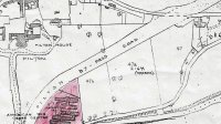
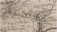
Map of the Broadgate Estate, Pilton, being sold in 1918
- from: Martin.Haddrill
- uploaded: Jun 10, 2013
- Hits: 21687
-
 (0 Likes)
This map is part of the catalogue for the Broadgate Estate being sold in May 1918. The text of the catalogue is available in the archive. Follow this link:
http://vimp.thepiltonstory.org/document/Prospectus-for-Sale-of-Broadgate...
The map was photocopied in four A3 sections and then scanned and recreated as a single picture. As a result, there are discontinuities at some of the joints. This does not significantly affect the understanding of the map but The Pilton Story team will try and re-do this to a better standard.
Thanks to the North Devon Athenaeum for this map which is based on the Ordnance Survey map.


