Pictures
French 18th Century Spy Map of the Taw and Torridge Estuaries
- from: Martin.Haddrill
- uploaded: May 1, 2013
- Hits: 9346
-
 (0 Likes)
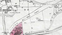
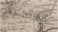
In 1768 the French produced a map of the Taw and Torridge Estuaries and hinterland showing the main habitation and geographic features. It was one of a set detailing all the ports and inlets on the southern coast of England and the Bristol Channel, drawn by a French spy in 1768 on a mission to discover likely invasion points into England.
As well as Barnstaple, Instow and Appledore, the map shows the locations of Pilton, Bradiford, Heanton Punchardon, Newport, Upcott House and it also mentions Pilton House (the recently completed home of Robert Incledon).
The key to the map is translated (with additional comments in brackets) as follows:
Plan of the Estuary of the Rivers Taw and Torridge
In the Bristol Channel drawn from memory on 21 and 22 October 1768
A. The Port of Barnstaple, reached at high tide by one hundred tonne vessels.
B. Stone bridge across the Taw, over which one passes to reach Torrington.
C. Lime kiln.
D. Rough knoll, where cannon could be placed (appears to be Castle Mound).
E. Queen Anne’s Square.
F. Mill on a small branch of the R. Yeo.
G. Stone bridge across the R. Yeo.
H. Pretty house belonging to Mr Incledon (probably Pilton House).
I. Fine manor house belonging to Mr Hearding (this must be Upcott House).
K and L Slightly raised dunes, where one could disembark between these two points (these are Braunton Burrows)
M. Significantly raised hillside, well cultivated and cut through by hedging, there are several squares of worked land but most of it is grassland
N. Sunken road bordered by hedging along its full length, continually dropping down towards the village at the end
O. Slightly raised hillside, cultivated and cut through by hedging
P. Hillside higher than the one at O, cultivated and cut through by hedging.
Thanks to Carol Haddrill for the translation and to Margaret Reed and Chatham Papers for the map.


